By HHA Members Tom Helmer & Rick Prescott
Photos By Bob Miner, Tom Thompson, Tom Helmer & RI DOT
In Hopkinton, the stats for this web site on the Home Page attest to the popular interest generated by illustrating the historic legacy that surrounds us. Our Web Pages do this with their many informative photographs, understandable text & maps; together they explain the “What”, “Why” and “Where” the otherwise mute archeology of our Town is important.
Hopkinton makes accommodation with it’s past. In my 25 years of residence in town, the New England character of “not throwing out the baby with the bath water” is clear. Progress and Preservation are active topics for debate over breakfast at the Brick Oven Restaurant.
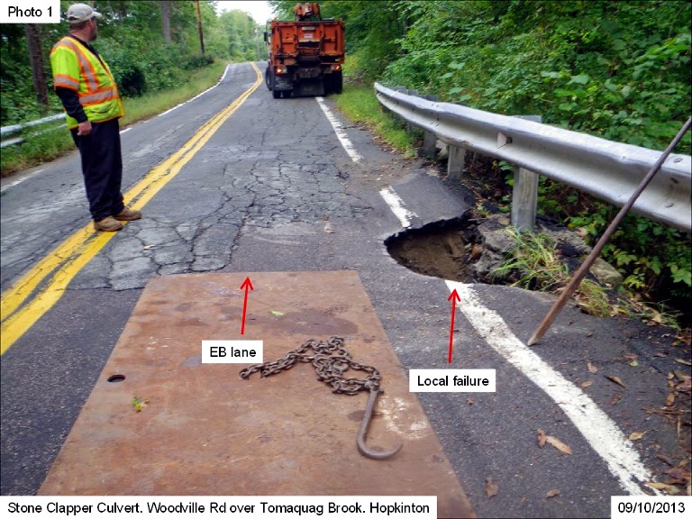
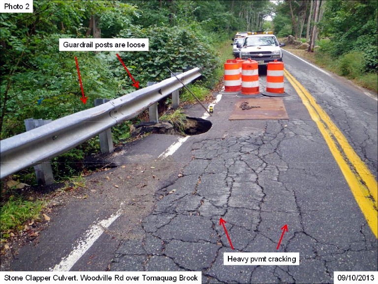
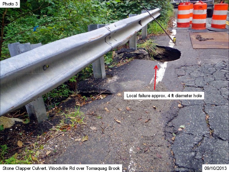
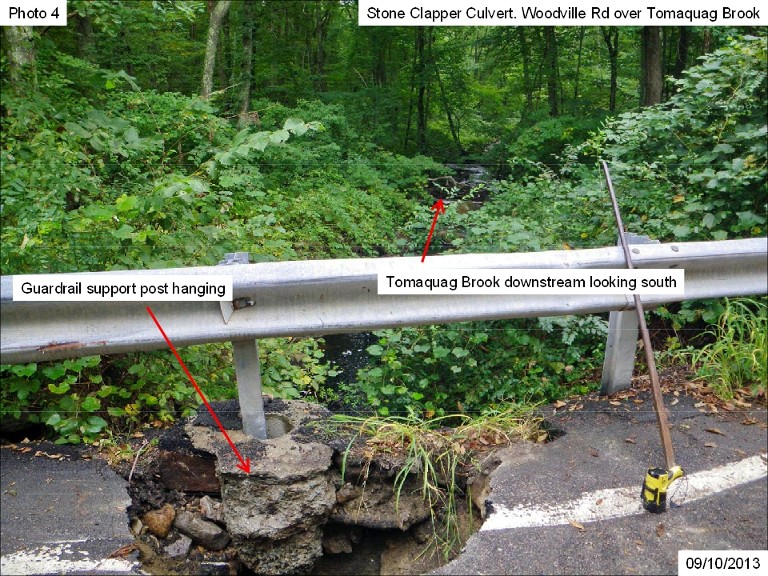
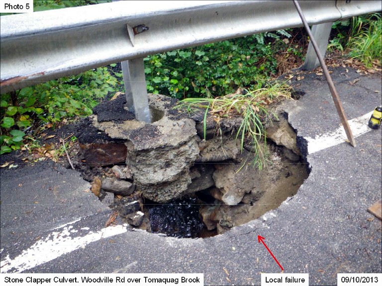
But there is no debate about safety. From time to time, the Colonial Era stone bridges that have been “Grandfathered” into our modern road network give out, or prove to be inadequate for current drainage usage.
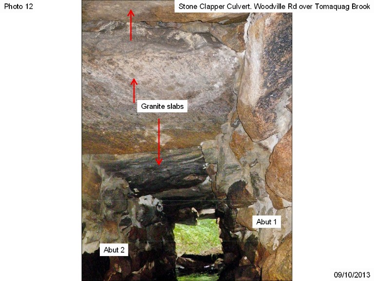
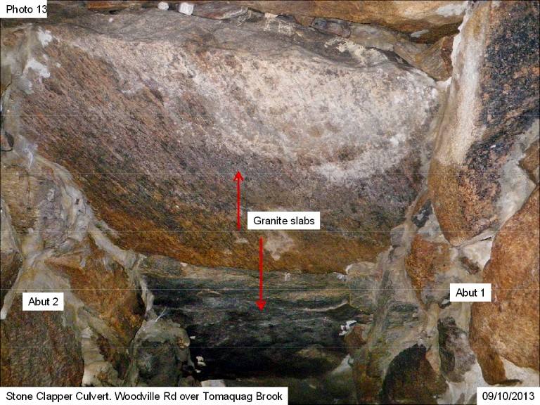
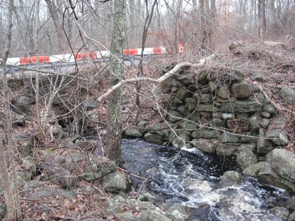
Such is the case at the culvert on Woodville road.
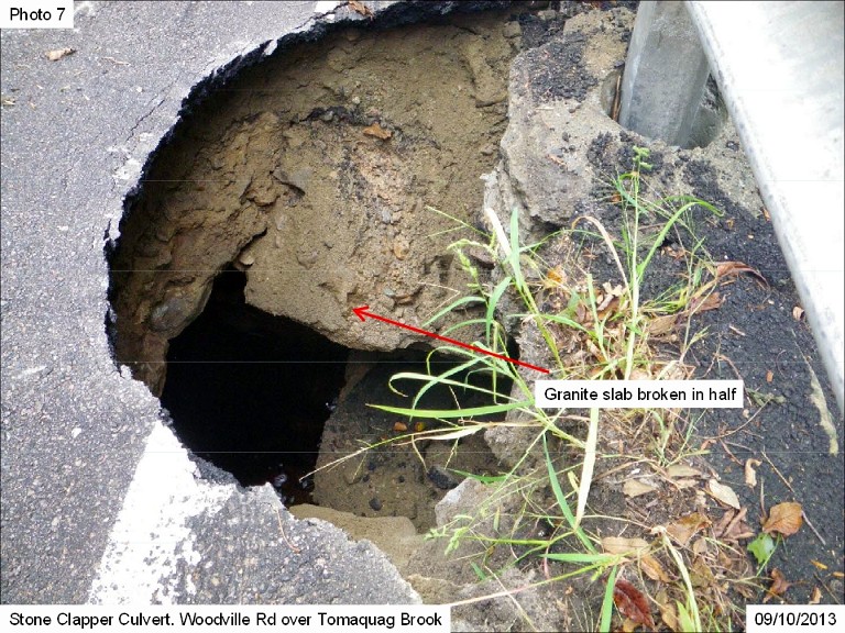
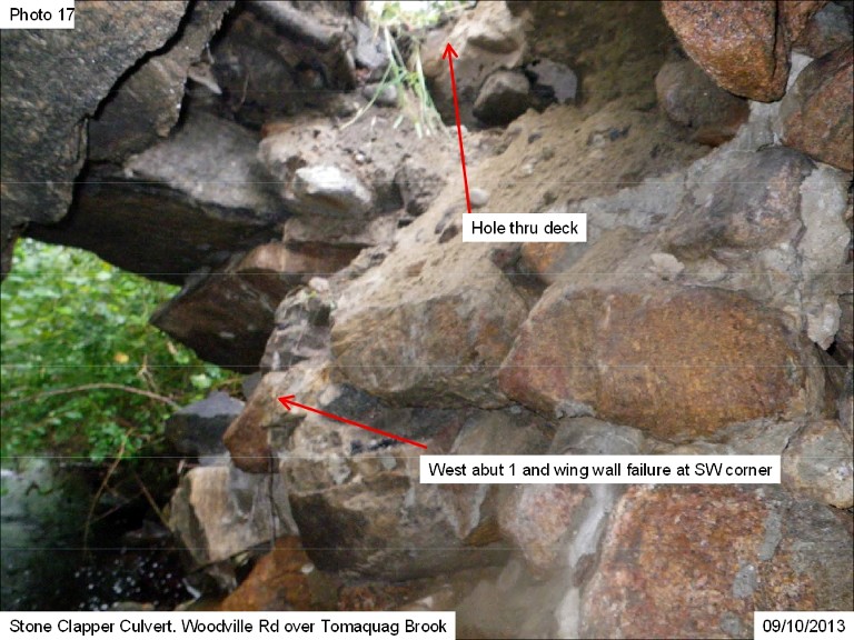
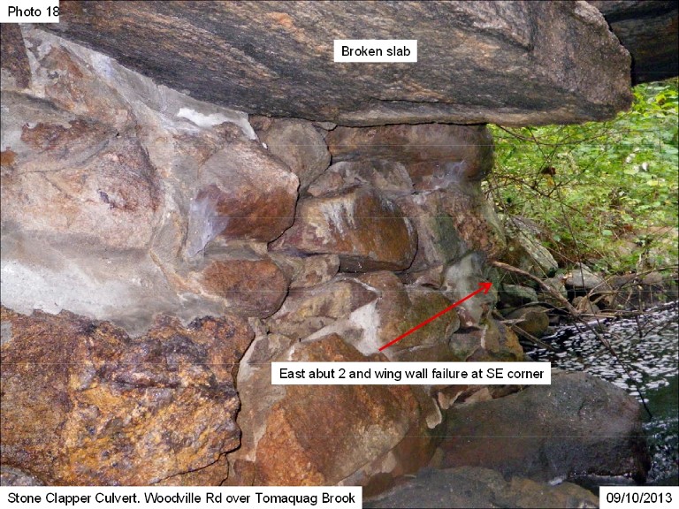
The cap stone on the South end has failed, and there is a partial collapse of this ancient culvert, rapidly and accurately identified as unsafe by our local Department of Public Works.
This web page will document the end of one historic era, and it’s replacement this year, in the subheading “Modern History”. Woodville Road, currently restricted to a single lane of traffic, will be restricted further, the old culvert will be dug out, a new pre-cast concrete culvert, engineered to modern specifications, will be installed, that section of Woodville Road will be re-paved with a “denture friendly” smooth surface, and after about a week, the historic stones of Woodville Culvert will be forgotten, except in these photos.
But there is another version to this story.
As of this writing, the RI State DOT intends to remove the historic bridge’s Cap Stones, and store them for future use elsewhere in the state at a holding area near Providence. But the Conservation Committee would like to retain those same stones for use here, retaining them in Hopkinton, and keeping their historic context to our town alive.
This is a new variation on the old “Progress vs. Preservation” debate.
The matter will be coming up for discussion with the Town Council shortly.
The hope of the Hopkinton Conservation Committee is our Town will request the State to allow these historic stones to remain in our town where they have long resided, only re-purposed into another use, rather than be lost completely to our history.
It turns out that the historic stones of Woodville culvert are now the baby in the bath water. However that debate is finally resolved, HHA will show the rebuilding of Woodville Culvert.
But from the perspective of History, to rebuild the culvert for safety is a “Win” for Progress AND the Town. To retain & re-purpose the stones in a new local setting is also a “Win” for Preservation AND the Town.
This is the “Win” / “Win” situation for Our Local History, which HHA supports.
If the stones get dumped in a field and re-purposed elsewhere, the world will keep on turning. The historic stones of Woodville Culvert will turn as well, turning back into anonymous rocks.
We will get to the results of the Town Council Meeting after more photos and info about the History of the historic old Colonial era bridge, now called a culvert.
[map]The location of the old Woodville Bridge / Culvert for Tomaquag Brook
There is a Progress AND Preservation debate concerning the use of the Historic Stones Of Woodville Culvert
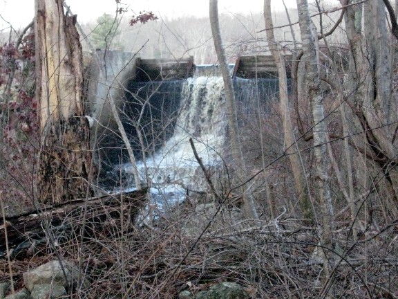
Events Of 12/02 13
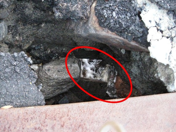
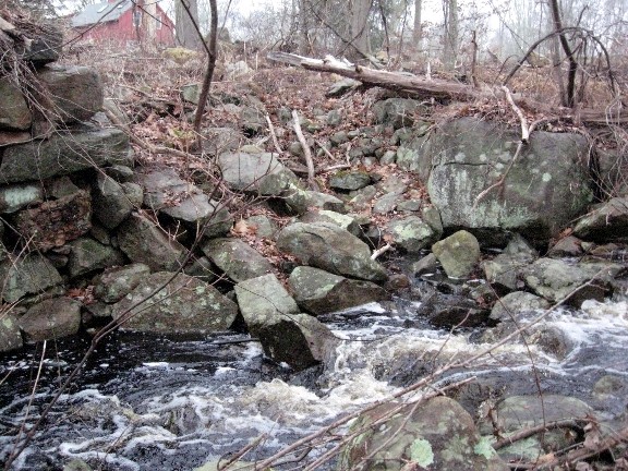
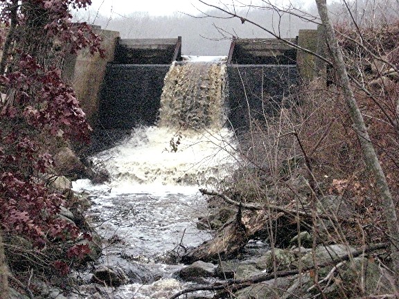
The Spillway leading Tomaquag Brook out of the pond and under the old Woodville Bridge / Culvert
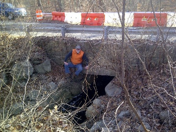
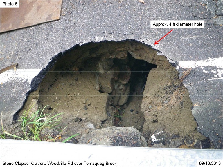
Old Woodville Bridge has suffered a failure in it’s ability to safely support the traffic that passes over it.
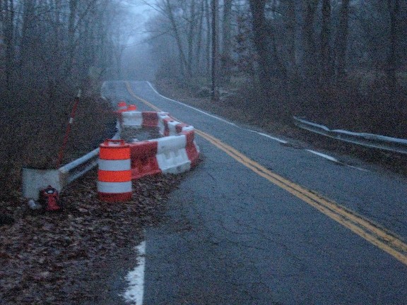
In the background you can see the red & white barrier that blocks off the far (Southern) lane of Woodville Road. Rick Prescott is measuring the length of the outside cap stone. The interior cap stones are just as long, and extend under the road surface for the entire width of the road.
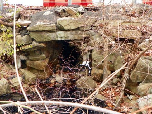
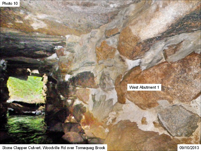
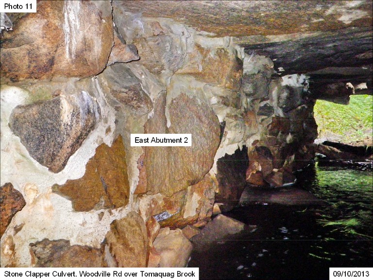
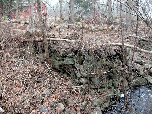
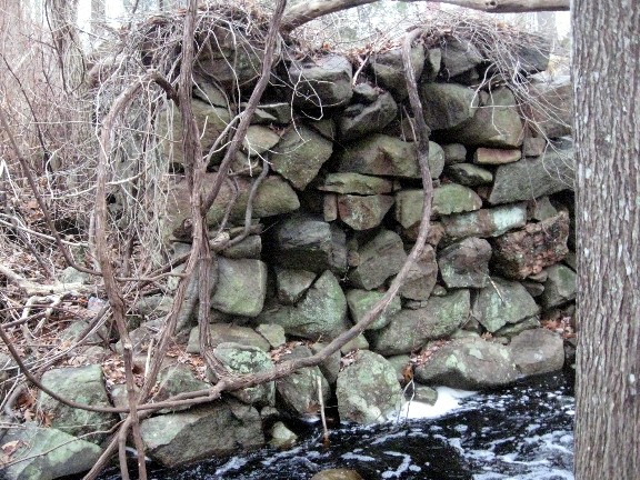
This is the “Upstream” side of the culvert, and you can clearly see the old stonework wall that protected this side of the road from erosion ever since the 19th century.
In the “500 Year Flood” of 2010, this bridge was overtopped by the waters of Tomaquag Brook, and portions of the road surface were scoured away. The bridge soon returned to service, but that flood may have sown the seeds for the historic bridge’s demise in 2013.
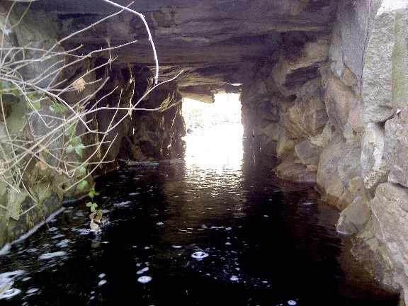
This is the view of the bridge / culvert beneath the roadway. You are looking downstream, from the North side towards the South, several days after the heavy Thanksgiving rains of November, 2013.
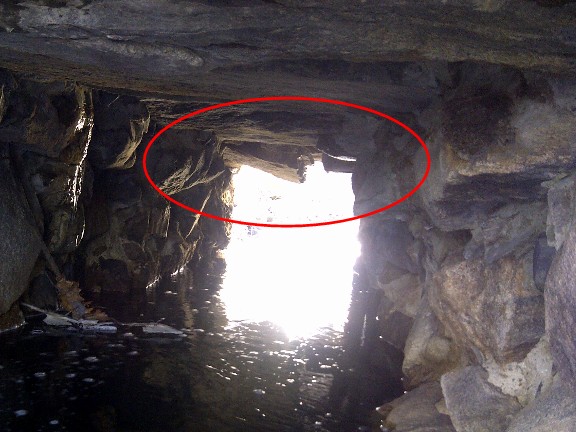
At the far end, you can see that the smooth channel the original bridge builders constructed is disturbed by a rock hanging down. This is the failure, and it will be shown more clearly in the next 2 photos.
These photos are taken from the South side of the road, looking upstream. They were shot prior to the heavy rains clearing the stream bed of accumulated leaves.


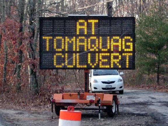
The State DOT starts to spread the word, a nice touch to warn the locals.
Rick Prescott forwarded the link to this web page to his friend in the State DOT to let them know there was a matter of historical interest brewing in “South County”. As you can judge, we set forth the case here for preservation of the stones locally with what used to be called “manners”.


At the Town Council Meeting, because the issue came up suddenly, there wasn’t enough time to get the subject on the agenda, so the Councilors could not take a vote on the matter. But there was a period in the meeting when any resident of the Town could speak on any matter.
Rick Prescott, who ended up representing all of the “Outdoorsy Groups”, presented each of the Councilors with a two page Photo Paper handout containing the pictures from the Web Site, which you have already seen on this page, along with a Text blurb reminding the Councilors that the people of Hopkinton take their history seriously.
(The cynic would say: “After all, we are talking about “used rocks” here, so what’s the big deal?”)
HHA tries to work via co-operation with the various agencies in town, and this was no different. Rick was polite, he made the case for the historic nature of the stones, he made no demands, he made requests that the individual Councilors inquire of the State DOT if it was possible they could change their plans. That same respectful attitude was also dominant in the Text blurb, which appears below. Please notice that your visiting HHA’s Web Site played a role in making the case that our local history means something to many people. (One thing Politicians can do is count votes)
As statistical evidence of the interest of the citizens of Hopkinton in their Local History, the Non Profit, Educational web site of the Hopkinton Historical Association currently supports 85 Web Pages, displaying 2,248 Photographs and 22 Videos. It has attracted over 3,400 “hits” from over 2,240 different individuals who have viewed a total of over 12,000 web pages of Local History.
Hopkinton’s Citizens are well aware of their local history, and actively support it’s preservation.
This is seen in the successful September fund raising campaign to save the Revolutionary War General Thurston’s Grave from a huge rotted tree. It was the Hopkinton Historical Association that was tasked by the Town Council to spearhead “Citizen Contributions”, which ultimately produced an abundance sufficient to also repair the masonry wall surrounding the cemetery which was severely damaged by this tree. Besides reading words, viewing pictures & actively volunteering, they also contribute their donations.
In conversation after the meeting, the town Council President, Mr. Frank Landolfi, indicated he would speak to one of his friends up in Providence, and he was true to his word.
Nothing much happened that I was aware of in Hopkinton, but late in the afternoon, Rick called me and said the State DOT has changed their mind. The State will still take the Cap Stones, but Hopkinton can have all the rest. Rick let Town Council President Landolfi know of this change of heart, and encouraged, he made another phone call to Providence.
The end of the matter was the State concurred that Hopkinton’s concern for it’s Local History, always couched in respectful terms, was of genuine concern to the Archaeologists and the Cultural Resources sections of DOT, and Hopkinton was granted permission to select what stones we wished to retain for our local re-purposing, and the State would take what we didn’t want.
As far as I know, no one raised their voice or was confrontational throughout the entire time this issue was percolating in the local and state agencies. Observing this trend from the sidelines, it’s like “Co-Operation” has become a communicable disease, and Hopkinton is Ground Zero.
It was wonderful to see this unfold!
Yes, it’s a little thing, just “used rocks”, but that bridge may have been built before the Revolutionary War. Now those rocks will serve as a new public connection linking us to “the People Before”, who lived & loved long before we arrived.
This shot was taken looking past the steel plate in the road, then looking down through the large cavity in the Old Bridge / Culvert at the foaming water of Tomaquag Brook below.
The State DOT starts to spread the word, a nice touch to warn the locals.
Rick Prescott forwarded the link to this web page to his friend in the State DOT to let them know there was a matter of historical interest brewing in “South County”. As you can judge, we set forth the case here for preservation of the stones locally with what used to be called “manners”.
Events of 12/4
The reasonableness of the informal communication concerning the overlooked historical component to the DOT’s routine decision to just salvage what they could and haul the rest of the rocks away as fill had an effect up in Providence.
A few years ago, Rick Prescott, President of HHA, made contact with Mr. Mike Hebert, DOT’s Historic Preservation Specialist / Archaeologist, who advised the DOT on issues related to historic sites in RI. At that time, Rick was preparing one of HHA’s Annual Presentations centered on the construction of Route 95 in Hopkinton. Route 95 was one of the first post war “Super Highways” to be constructed under then President Eisenhower’s “Interstate Highway System” guidelines.
Mike Hebert was very sympathetic to Rick’s research, and allowed him access to the voluminous photographic records the DOT has taken concerning most construction projects undertaken in RI. The pictures Rick obtained were of excellent quality, and meticulously documented every step of Rt. 95’s construction in the middle 50’s, including aerial photography!
(You can see Rick’s use of these pictures on the Web Page “Building Route 95, Part 1” and “Building Route 95, Part 2” by Richard Wolke, President of the Richmond Historical Society.)
Rick had e mailed Mr. Hebert on Tuesday, including a link to this page, and explained the historical nature of Hopkinton’s request. The problem we had was important to Mr. Hebert. He went into those same Photo Archives and sent back to Rick 21 photos that DOT used to document the problem, correct any immediate safety problems, and be instrumental in planning DOT’s recommend permanent repair of Hopkinton’s transportation problem prior to the onset of winter.
The pictures appear below.
But before we get to them, I am impelled to make a personal observation about the DOT, DPW and Highway workers in general. (Uh OH!)
Like at least 95% of everyone in America, I used to subscribe to the theory that all highway workers required 3 people to lean on shovels supervising while one person did something.
It’s OK to nod your head at home in agreement.
I was never in a situation where I could see anything different than the stereotype, usually based by driving slowly through an infuriating delay and spotting someone, anyone, not sweating bullets to let you go faster.
But in preparing the web page “Rebuilding Woodville Bridge”, the companion aftermath page to “The Flood Comes To Woodville”, I looked in the many photos taken of that construction job for the “3 guys w shovels supervising”, but they were not there! Instead, I had photo after photo of Cardi Corporation employees working Purposefully, Safely and Skillfully, completing a difficult job in a First Class manner promptly. I was so amazed at the efficiency clearly visible in those 22 photos that I wrote about it on that page.
And my highway worker “3 Guys” stereotype had big cracks in it now.
The shattering of that misconception occurred when I studied the pictures from Mike Hebert.
They show a 1st class organization analyzing a problem from one of the state’s many towns, formatting and documenting those photos so someone who has never been to Woodville Bridge/Culvert can understand and make a decision about what to do. But I am always looking at the human side of things.
QUESTION: How would you like to be the one having to get into the brook, with slippery, uncertain footing, and wade underneath a bridge that is already known to be collapsing, taking pictures like a tourist visiting the dark, scary tunnel full of spiders and snakes?
What I am saying is: I went from “3 Guys”, to recognizing that I was mocking a well organized group of Professionals, using highly refined Engineering Skill & Experience, doing a job I would totally fail at, should I be asked to trade places with any one of them.
You look for yourself at “Rebuilding Woodville Bridge”, then look at the next 21 photos. My experience as webmaster lets me know how much labor it takes to format and annotate a single photo. To whoever did this, I say “Good Job!” Plus the same commendation to the one who waded under the bridge! Then look at the date stamp on the photos. On September 10, 2013, the DOT crew showed up at the scene of the failure, confirmed what the local DPW said, documented the problem from above and below, then implemented a temporary solution that kept the local drivers, myself included, able to pass on Woodville Road safely. All in one day!
Look at the photos and then check your “3 Guys” stereotype for cracks.
If your saying stuff like “I never knew they did this!”, You are correct. John Q. Public has no idea of what goes into planning and executing a DPW or DOT project. It was only the accident of me preparing a web page on the big Woodville Bridge that I got my first hint that my thinking was off. Perhaps there is another winner in the decision to allow Hopkinton to retain it’s historic stones.
The web site stats indicate that over time, a whole lot of people are going to see this page, and some of them are going to shed their personal version of “3 Guys”!
But enough already! Thank You, Mike Hebert, for the photos!
Note the “hand cut stone Drill Marks”. The old boys wanted the outside Cap Stone to look good!


“OK, Froggy, into the brook you go. And don’t drop the camera!”


This is the day we got the word that Hopkinton would get first pick of the stones!
Mr. Barry Simpson, the DOT’s man in charge of Cultural Resources, who works with DOT’s Archaeologist, Mr. Mike Hebert, called Rick Prescott with the good news!
Rick, in his best Paul Revere imitation, though it wasn’t the middle of the night, and he wasn’t galloping about on a horse, none the less spread the word that “The Cap Stones Are Coming!”
Events of 12/5/13
With demolition scheduled to begin tomorrow under drizzly skies, I went to the Bridge site to get the photos needed to show you how Woodville Road has changed over more than two centuries of time. To do this, I do not need Mister Peabody, his pet boy Sherman and the WABAC machine, besides, they are busy on “Hiking Tomaquag Trail”. Three pictures will convey the explanation Rick brought to my attention.
A small Colonial era bridge begins with a ditch to carry the water. It is banked on both sides with parallel stone walls raised to the height appropriate for the intended 4 Season roadway. Those twin walls are covered over with large, thick, closely fitted flag stones, called “Cap Stones”.
In the forests of Hopkinton, the bridges that remain as they were built in the Colonial era are all a minimum of 10 feet wide, allowing a large farm Ox Cart to safely pass. Way back then, it is probable, but not certain, that this bridge began at that “Single Lane” width.
But certainly, as traffic grew in volume, Woodville’s Tomaquag Bridge would have expanded in width. But keep in mind that it was only after WWI, in the 1920’s, that Hopkinton began to shift over from 90% dirt roads everywhere to actual 4 Season pavement.
As web site visitors from some of the 50+ countries that “hit” on our site can see, Woodville Road traverses a number of hills. Back in the day, hills were a part of country living. It was the seasonal mud that was the problem. For many years, it was the land owner’s responsibility to keep the public road fronting his land passable, and in repair.
Every resident of Hopkinton was the Department of Public Works!
The original bridge builders were also private citizens, perhaps compensated by the Town, but maybe not. The Tomaquag Brook Bridge on Woodville road seems to have had a very fancy feature built into the original construction. Atop the series of cap stones, which were all exposed, they built a wall to keep your Ox Cart or wagon from falling off the bridge, relatively high above the brook level.
As a nice touch, the straight cut stone edge was exposed about six inches, and then the wall was built atop the Cap Stone over the channel, but extended down to brook level or lower on the sides. The wall appears to extend up about thirty inches higher than the cap stone. This would be a practical safety feature for wagons, as well as providing a nice seat for passing the time of day fishing for “Brookies”, conversing with the neighbor 3 miles down the road, or that nervous first kiss, sparking with them mysterious creatures of the opposite sex.
All in all, it was useful for the majority of it’s existence as the guardian over Tomaquag Brook.
But today, unless you are a “smurf” sized hiker, you need someone to point the wall out to you. The next 2 pictures give you an “End” shot, then a “Road Kill” view of the 6” wall.

So what happened to the wall? The question has a companion? What happened to the Cap Stones that would be exposed all the way across the road?
The answer is the same for both questions.
The “Motor Car” happened.
When you are traveling at 2 Miles per hour in an Ox Cart, or 4 in a horse drawn wagon, neither of which have a luxurious suspension system, clomping and jouncing over every bump was the price you paid for the luxury of not walking. When the automobile would hit those cap stones at a breathtaking twenty miles per hour, three things happened. The first was you got to experience a brief moment of weightlessness until gravity returned you to your seat. The second was the chance you would pop an inner tube, or break a wheel, or an axle would fall off. The third was you could jar one of the cap stones sufficient that eventually it would shift and dump you into the brook, and then it would fall on you.
So they dumped two feet of fill over the capstones, eased out the dip in the road, and paved over the top of everything. In the Photo Tour “The Bridges Of Old Hopkinton”, you can see two other bridges that have been “Grandfathered” into the transportation network in this same fashion. One is a little “trickle Brook” on Tomaquag Road, the other is over Wine Bottle Brook, which has a major bridge, also on Tomaquag Road. But you will never see them, unless you get out of your car, or, visit that web page!
All three alternative results to bridges which had exposed Cap Stones were major irritants, even in those mellow sepia toned days when grandpa was a crazy young man, willing to try any fool thing, (Does that sound like anyone YOU know?), because what could possibly go wrong in an Automobile! It’s a Machine, not an Ox or a Horse, and can go anywhere!
I met the property owner, Mr. Ed Carapezza, his wife Marsha, and Steve Ferrance, out working on his land, trying to beat Winter. All were extremely interested in the history of their land, and were knowledgeable about Indigenous History as well as Colonial History.
But they were definitely interested in the project that would impact their land, and their old saw mill ruins, ten feet upstream from the current bridge. Rick Prescott gave him a copy of an old document that describes the saw mill and the people who owned this land before.

THE SAWMILL ON WOODVILLE ROAD
This sawmill was located between its mill pond and Woodville Road. It is shown both the 1870 and 1895 maps of Hopkinton.
The following paragraph was written in the 1880’s by Alfred Amos Langworthy, who lived from 1841 to 1912 in Hopkinton’s Tomaquag Valley. His hand written manuscript was found in the Westerly Library and transcribed by a member of the Hopkinton Historical Association in the 1990’s.
“The general occupation of the people of this valley has been farming. Dairying and raising fruit has held quite an important place among its inhabitants. Large quantities of most excellent butter and cheese has gone into the market from this valley and also bushels of nice fruit. But aside from this, there were anciently three distinct industries located on Tomaquag Stream.
The first we will mention was a saw mill, which was located where the Tomaquag Stream crosses the highway running from Hopkinton City to Woodville. Said sawmill was first built many years ago by Josiah Witter Sr. [Witter lived from 1739 to 1828] Later this mill was run by Barney Crandall.
After a time it when down, but since the memory of this writer was partially built up by Nicholas Crandall, [Crandall lived from 1808 to 1889], and was completed by Nathan Baber Palmer, who bought the [water] privilege. Mr. Palmer has done quite and extensive business here sawing lumber for many years. It was during later years familiarly spoken of as the “Barber Palmer Sawmill”. The dam and old water wheel are still visible there.”
The following quotes were written by Charles J. Norris, who wrote a column on local history in the Westerly Sun entitled “Town Talk of Yesterday” in the 1930 & 40’s. Here he tells of Barber Palmer’s work as a sawyer.
“Barber Palmer was industrious and worked long hours. Early and late could be heard the clatter of wheels the buzz of saws through bark and heart of tree trunks of hardy oak, chestnut and pine trees all of which were grist for his mill.”
“It is related that he didn’t wish to spare the time for his meals when there was timber to be cut into lumber, but would eat while the machinery whirred late into the night by the meager light of lanterns. His doughnuts and cheese were eaten between times, as opportunity occurred. He was a busy man, thrifty and true to his word – a good citizen.”
“The Barber Palmer sawmill is passed and the trench which once led water to the wheel of a busy industry is grown up to brush and weeds.”
Recently 93 year old Fred Kenney of Hope Valley said that his brother helped rebuild the dam in the early 1950’s. At the time he worked for the Fitzpatrick who then owned the property. It appears that the dam that was built is somewhat higher than the original colonial dam. A levy was put in place along Woodville Road to prevent flooding in high water. During the 2010 flood, sand bags had to be used to fortify a break in the levy and they still can be seen there.
At the end of the day, I was all set with my background photos, and Woodville Road awaited the arrival of the work crew, bright and early tomorrow morning, around 7 A.M.
I was ready also, with a home made waterproof housing for my camera, and a determination to not let inclement weather keep me from getting the photos of Modern History.
Events Of 12/6 & 7/13
It was a December dawn, with a cool drizzle in the 40’s. Not wanting to miss the opening preparations, I was there before 7. The road was devoid of traffic. Then, out of the “Hound Of The Baskervilles” gloom stepped Rick, also early for his meeting with Tim Tefft, who runs Hopkinton’s DPW, Dave Caswell, a key man in the DPW, and Jack Graves, the Job’s Field Manager for Northern Construction Services, hired by the State DOT to do the demolition, site prep, installation and the site repaved and cleared out in only 6 days. It is an ambitious time frame!
But DOT wants it done before Winter Storms hit.


Thank You, State of RI DOT!

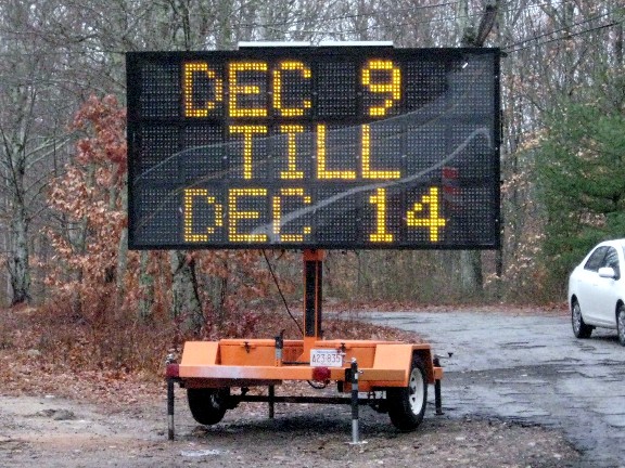
It turned out that work would not begin today, Friday, 12/6. The new date is Monday, 12/9 -Saturday, 12/14 Both road signs were changed to reflect the new dates
Rain is forecast for Monday, but the Geese are unfuffled by this.
However, I took the precaution of setting up a plastic tarp over my “Base Camp” in the woods, where I can at least retreat out of the rain when not shooting photos.
The first thing I did was have a literal “Open House” Party!

Events of 12/9/13
The First Day Of Demolition
The weather could have been worse, as my niece was ice skating on the road in Dallas, Texas the day before. But it was a bone chiller, with a steady rain. The Hopkinton Police, then Jack, then the Crew all showed up at their new “Office”, and sleepy Woodville Road woke up to a new day.
I do not have time for commentary, all I am posting for the next 6 days are slide shows of what the Crew from Northern Construction, and the State DOT, and the Local DPW accomplished.
IMPORTANT! There will be over 130+ Photos displayed in Slide Shows coming up. Look for a grey/black band at the bottom center of these pics. Click on the “VCR” play triangle to start the show. Pics will auto cycle every 5 seconds.
[slideshow]History Moves On
Keep in mind that thanks to the Hopkinton Town Council and other polite but vocal residents, and the State DOT, and Mr Barry Simpson, the Department Head of DOT’s Cultural Resources, the Historic Stones Of Woodville Culvert will be re-purposed in Hopkinton!
This was a Good Job by all parties involved, with a super fast, decisive reaction time!

Events Of 12/10/13
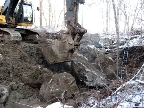
The second day of Site Work was devoted to demolition of the old bridge. Later on would come laying down 18” of gravel as a bed to serve as the foundation for the concrete culvert construction. But first, the Excavator did it’s thing!
IMPORTANT! There will be lots of Photos displayed in Slide Shows coming up. Look for a grey/black band at the bottom center of these pics. Click on the “VCR” play triangle to start the show. Pics will auto cycle every 5 seconds.
Be sure to also watch the 3 videos of what this Machine & Operator can do!

Events of 12/11/13 A.M.
Pre-dawn on Wednesday, the 3rd day of Construction, brought a clear day, but well below freezing. There were “Weather Alerts” out for “Black Ice”.
For those not from the Northern Latitudes, Black Ice is a term for what is usually a thin layer of wall to wall ice that is the result of snow melt the previous day, or a light rain that freezes in plunging temperatures. It thin coat on everything leaves you with zero traction when you hit a patch. And where a normal coating of snow or ice will leave a characteristic white or grey color, Black Ice looks just like the pavement, because the coating is so thin.
Arriving before 7, I got my charcoal burner lit to ward off the chill in my continuous “Open House” Party in “Trollville”, then followed the sound of the “Clunking” to the start of the day’s activities.
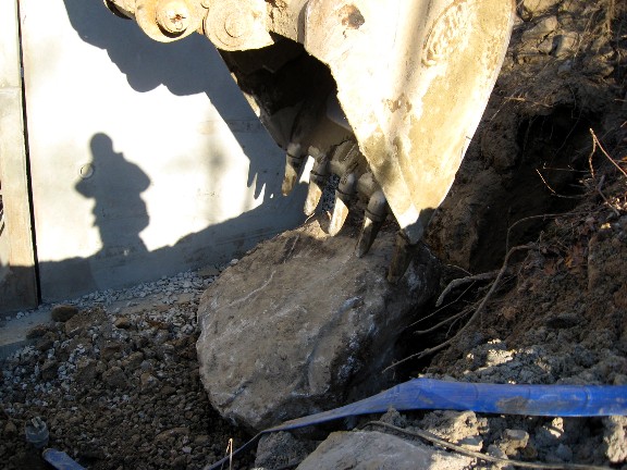
After I left the site yesterday afternoon, The Northern Construction Service Crew had removed all trace of the old Bridge / Culvert. They left the Colonial Saw Mill ruins undamaged. They then had roughed out the length of the excavation required for the new culvert to carry Tomaquag Brook, and the gap was wider than required, so the sides of the hole were stable and unlikely to slide down.
They were now shifting into the Culvert Construction phase. Essentially, they have to create a stable foundation for the culvert sections, 5’ by 5’ in cross section, to sit on. They extend the trench deeper, lay down a special cloth blanket, cover the middle of the blanket with 18” of crushed stone, nestled beside long concrete beams, lying in the same direction as the road, a pair of beams at each end of the dig. These beams will support the two end sections of the cast concrete culvert, the gravel holds them in place, like the stone ballast holds railroad ties.
I thought I saw the big rocks get scooped out, but down below lurked these monster rocks, deposited by the glacier. These were so big, that while the excavator could lift them, lesser excavating machinery would not be able to do so, so the rocks had to be broken up. The banging and crashing I heard was the Excavator operator lifting up a huge rock, then dropping it on another. A few whacks, and one, the other, or both split.
As Inspector Clouseau would say, “Zee problem is soll-vedd”.


The crew had actually completed the first of multiple bands of blanket & crushed stone, but lacking X-Ray Vision, I could not see their progress under the accumulated seepage into the Construction Zone. While the diversion pump carrying the flow of Tomaquag Brook ran all night, still, water percolates in from the surrounding high water table.
This puddle hides the first pair of beams and the crushed rock.
Soon the pump will drain this, adding it to the sediment accumulating in the filter bag.


The huge rocks continue to be broken up and hauled away. It’s too bad there is a section of Hopkinton already called “Rockville”. If the Domain Name” was available, we should grab it up.
We will have plenty of “Historic Rocks” when this is done.
Meanwhile, the sunrise begins to clear the tree tops, and I wander over to Woodville Pond.
The current population of Canadian Geese are sitting on the ice at the far side of the pond, enjoying the scanty heat available in the slanting rays of sunrise.


Meanwhile, back in the excavation, the suction pump has done it’s job, and you can see the first blanket, stones & beams section emerging from the muddy water, which must be filtered before being returned to the brook by the huge bag, my next door neighbor in “Trollville”.
Before I had to leave the site late this morning, they had another section of blanket & stones laid down. The ends of the blanket, which line up with the roadway, will be folded over the stone, trapping the crushed rock in it’s current position before the site is filled.

Events Of 12/12/13
“Dilemma Day At Woodville Culvert”
This project has been on a “Fast Track Timeline” well before the Construction Crew arrived on site. Today, one tiny error, perhaps less than 1”, that snuck through all the drawings and manufacture, finally had it’s chance to knock the schedule back 3 hours of field time, but overall shifting the completion date a full day to Monday, 12/16.
This is a Late Fall Highway Project, and construction is in a race with the weather, and the fact that asphalt plants shut down once it gets cold. The plant making the asphalt for this job graciously stayed open over the weekend to accommodate Hopkinton’s need. Thank you from this local driver for that!
There are three slide shows. By now you know the drill, put your cursor over the faint grey bar at the bottom of the slide show, which will become prominent. Then adjust it like a VCR. The slides change every 5 seconds, but you can change that rate. Click the timer and see your choices. You can also advance to a photo, or go back. It’s quite versatile.
On this day, I get around to introducing the people who are doing this work. We drive by nameless “Highway Workers”, and that was OK for the first few days on this job, but now it’s time to give you some names to go with the faces. At first, I am only dealing with the Field Crew from Northern Construction Services. Jack, the job Supervisor, has four men to direct. Herb, the Operator of the Excavator, Alex, also an Operator of excavators as well as the massive Volvo dump truck, Glenn and Ed.
That’s it. Five men to do this job. Outdoors. In “Whatever Weather”!
(I warned you that viewing these photos would be hazardous to your “3 Men Leaning On Shovels” stereotype. But you never get the chance to see EVERYTHING that has to be done.
You can drive by Herb, sitting in his cab, and think “He ain’t doin’ nuthin”!
But Herb is holding 10,000 pounds of concrete in a precise location, waiting for Glenn to give him a hand signal to move it slowly, just one inch to the right.
What you think is inaction on your muttering “drive by”,
is the natural rhythm of a crew working together in safety.
And on this crew, it’s Jack, Herb, Alex, Glenn and Ed.
Whatever problems come up, they have to solve them,
because the clock and calendar don’t wait.
As the work progresses, I will introduce you to the many DOT Inspectors that monitor their progress,
and keep the job working to the precise construction specifications & environmental codes.
Every face in the photos has a name. And they all take their work seriously.
I know, because I have been with them every single day, recording the Modern History of Our Time.
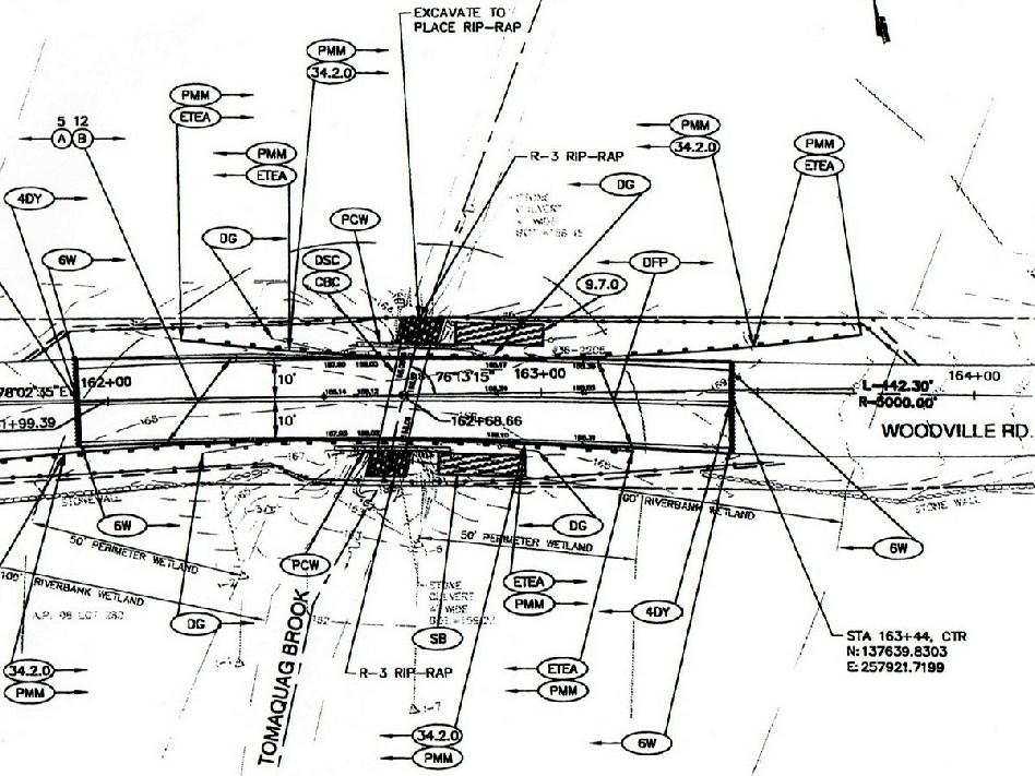
The DOT Construction Blueprints For Woodville Culvert
The first print is the view from directly above the culvert. Woodville Road has a gentle radius (curve) to the pavement going over the bridge. Tomaquag Brook goes under the road at a slight diagonal.
As for all the other details, Rocket Scientists have it worse, but I know from being on site for the duration, there is a lengthy list of construction & environmental specifications and standards to be met.
The second print is a worm’s eye view from the side. By now you should be able to locate the concrete sections that have been assembled down in the hole. Additional details shown on this print are:
There will be a natural rocky stream bottom inside the culvert. The brook will not be running over bare concrete, rather, two feet of rip rap rocks, which will soon be home to assorted algae, bugs, and hide outs for fish. This is a nice touch. Those 2 feet of rock will be shoveled by hand, not machine, into the culvert.
The designer indicated the “100 Year Flood” level on the print.
Trivia Question Winner! How high is the pavement of Woodville Culvert above sea level? About 168 feet!

This is a de-cluttered view of the Concrete Culvert passing under Woodville Road
Please Note the Very Fancy North Directional Arrow.

This is a view of either end of the culvert from the Brook’s viewpoint.
The grade down to the brook will showcase the first use of Hopkinton’s being able to re-purpose the historic stones. The rocks used on the down slope grades will not be freshly crushed large size stones. They will be the smaller rocks that were taken during demolition, or several gigantic glacial erratics that were dug out far below the old Colonial Bridge Structure. All of these are the Historic Stones Of Woodville Culvert, beginning their second tour of duty on the new Woodville Culvert. Unlike fresh crushed rock, these old weathered stones will look right at home here, and in a few short years will carry the lichen / moss patina of the nearby undisturbed rocks of the old walls and archaeological features in the nearby forest.
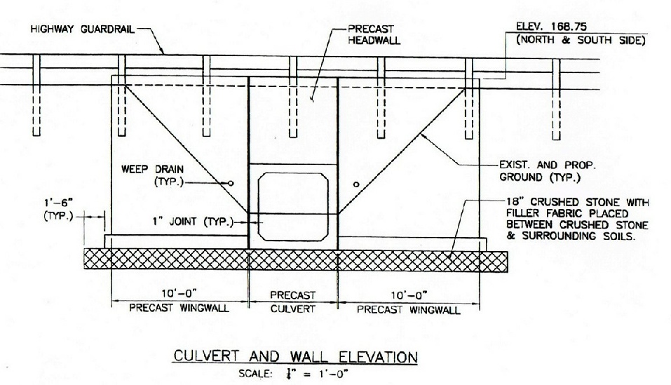
This is a close up of the cross section of the culvert that Tomaquag Brook will pass through. Please note that while the concrete tunnel is 5’ X 5’, there is a 2’ thick rock bottom. The brook will have a 5’ X 3’ cross section to flow through, over the 2’ rock bottom.

Events of 12/13/13
Jack & Crew come roaring back against the clock & bad weather
I was talking with Glenn in the pre-sunrise gloom about how impressed I was with him, Herb, Ed and Jack during the three lost hours trying to identify, and then get around, whatever the alignment problem was on the first Wing Wall installation. No one lost their cool, no one started throwing stuff.
Jack and all kept their emotional cool
(The temps were around 20, the wind chill was in low single digits. I shoot photos with a bare hand, and it was FROZEN!)
Glenn replied: “There are no problems, just solutions”.
Well they found the solution to the alignment problem, which will show up in a “Pop Quiz” for you in one of the slide shows, and put up each of the remaining wing walls in 20 minutes or less for each.
As the Culvert progressed to completion, Jack began looking ahead to the sixth day of construction. On 12/14, they had to install the artificial “natural” stream bed inside the culvert, completely fill in the inside portion of the bridge, and finish grade the slopes on the outside portion. Stone had to be laid down for the new road bed, and the whole new roadway asphalted & rolled.
The problem was the weather. A bad snow storm was predicted for Saturday, 12/14, & Sunday, 12/15.
Snow & Asphalting on frozen ground don’t mix. Trouble’s a-brewin’. Stay tuned to this page!
There will be a mix of slide shows, fixed pics & videos. Keep on your toes, people!
Herb begins to grade the slopes down to the brook.

Gently placing this monster on the far side of the cut is why his track lifted up. A boulder this big, if it rolled against the wing wall, could cause major problems. Jack says Herb & Alex are “Surgeons”.
Adjusting the boulder. Note in the background the historic rocks already placed to form the grade.

WARNING! This text block with the Blue Border requires IMAGINATION.
If you are a serious person with no time for this kind of stupid foolishness, skip down to the next regular text block, one with invisible borders.
Oh by the way, how can you “see” an invisible border?
A-Hah! You DO have an imagination!!!
🙂
As previously noted, the stones used to grade the sides of the road down to Tomaquag Brook are taken from the stones preserved from the demolition of the Colonial Bridge, and intended for re-purposing in Hopkinton. This is the first use of those re-purposed rocks. In a few years, after the weather washes off the dirt, and the lichen and moss expand into the new surfaces, they will look like they have been here for a long time.
In contrast, imagine newly fractured Rip-Rap, the color of the stones in the wing wall dead man anchors, or the larger Rip Rap used in the newly constructed stream bed, climbing up the slope. They would jar the senses, and proclaim their “Norman Newguy” status with incandescent luminosity.
These Hopkinton stones are right back where they have rested for 250 years!
Some people, perhaps visitors to this site, may believe that sentience extends to everything on the planet, that even rocks are self aware.
I don’t feel that way, but the world is a big place.
As Young Han Solo famously said to Old Obewan Kenobe:
“Old man, I’ve been from one side of the galaxy to the other,
and I never heard of no “Force” thing, holding everything together.”
Old Obewan just nodded and smiled at the young man’s assurance.
So, here comes the Imagination part. Follow along as I postulate the emotions of a thinking stone on finding out it is back where it came from, just one week ago. (a measure of time to a rock that is faster than the blink of an eye to us)
The rock would recognize it’s old companion the brook, and this would make it happy.
The disturbance of being hauled off would be dismissed as some odd feeling, one that passed as quickly as it came.
And, speaking frankly, the stone would be glad to have some new neighbors! Imagine you were rubbing protrusions with your neighbors for 250 years,
since your last move around 1760.
You know all their stories and jokes.
They know all your stories and jokes.
Even for a rock, that would be boring!
“Knock Knock”
“Who’s There?”
“I’m Getting”
“I’m Getting Who?”
“I’m getting sedimental over yooou!”
This next one’s even worse! A “Rock Theology” limerick!
A Hopkinton rock in the ground,
Was tumbled and shaken around,
Instead of the night,
He savored the light,
And sang he was Lost now he’s Found!
Sheesh! Two hundred and fifty years of THAT STUFF! And you can’t escape! YIKES!
There is always one in every crowd that will complain about eroding.
Comon! We’re ALL eroding! Give us some news!
Most rocks accept their personal disintegration with equanimity,
compensate to use what they still have,
don’t whine about the universal experience,
and get on with the business of being what they still can be,
before heading off to the “Great Sand Pile In The Sky”.
(I hate whiney rocks, don’t you?)
So, for those who believe these stones can think,
they have to believe they are very happy now.
And, if you came out to visit them at the new Woodville Culvert,
they would absolutely love it!
I previously mentioned that Jack describes his excavator operators Herb and Alex as surgeons.
Well OK, maybe you don’t want Herb removing your appendix with that excavator, but this video, as well as the photos you have already seen, will show you better than I can tell you.
Herb ids setting the historic rocks on a steep slope. To help the rocks “stick”, he also has to spread dirt over them, but not too much so the get covered. Glenn says a skilled operator tries to get things done with a minimum of extensions & lifts. Here is a brief explanation of the craftsmanship in the video.
The first thing in the bucket is a mix of dirt and small stones. Then Herb fills the bucket with the bigger old rocks. The lift proceeds, the big rocks for the grade come out of the bucket first. (Last In, First Out) Once the grade rocks are placed, he then sifts out the dirt, which will be carried by the rain & snow down around the base of the rocks. Then he either moves the occasional stray, or tamps down one that protrudes. Then it’s back for more, keeping the excavator moving.
Important Temporal Displacement!
If Indiana Jones drops a 1932 quarter while running through an ancient temple, and an archaeological expedition finds that quarter while digging in 2013, they do not assume the temple was built in 1932, they assume that something modern intruded on something in the past. This is called a Temporal Displacement, and everyone reading this is about to experience one.
On the events of 12/13, I, like everyone consulted about the alignment problem, believed that there was a mistake in the placement of the bolt inserts in the Wing Walls.
However, on Dec 16, I was informed that the bolt holes were in fact placed correctly, and I was told that the Wing walls were not intended to sit flush w the central conduit.
My apologies to all involved, but what I wrote for 12/13 is what was believed in the field at that time. This correction has been dropped into the past, 12/13, from the future, 12/16, so everyone knows what the current hindsight conclusion was/is.
Events Of 12/14/13
This is the day we were supposed to get hit with a heavy snow late in the day, plus winds from 20 – 40 MPH. As my hand was loosing feeling when exposed to snap a shot, there were few photos this day. But the crew, plus 2 more men to help with shoveling the 2’ of rip rap into the culvert, made good progress. Oh, by the way, it is not yet Winter.
The project has officially been moved to a Monday, 12/16 completion date, due to the alignment problem and the snow due this day, the scheduled completion date.
Stay tuned. I don’t know what the weather will be tomorrow, just that the Pats lost to Miami.
Events of 12/16/13
Weather dominated the events of this day. It was clear, cold & windy. They were expecting the paving crew to show up, but those plans fell through. Jack & the Crew packed up their equipment, completed the back filling, released the brook from the upper & lower sand bag dams, and remover the layer of sand that was soaked by Sunday’s snow & rain. When Herb peeled this layer off, it sounded like the teeth of his bucket were scraping through concrete, but it was just hard compressed, frozen sand. The rumor was they would pave on Tuesday, but another snow storm was forecast. Uh-Oh…
When I left the site, to pave, or not to pave was still an active question.
Tomorrow morning will tell the tale…
Events of 12/17/13
The storm will start early, but hit hard in the afternoon. John, the Crew Supervisor for the Lynch paving contractor assured me they would get the job done right, pack up their stuff, and let the asphalt, laid down at 270 degrees F., Set up overnight, then another crew would come in Wednesday and put up the guardrails. There are two slide shows for this day’s events and a video.
In these photos, I give the names of the State DOT inspectors who made certain that all the testing was done, specifications were met, and the environment was protected. Some of these DOT Inspectors I may have missed, and I ask your forgiveness for not getting your photo or name.
After the video, I reviewed all hundreds of photographs I formatted on this page, and selected the one picture that I felt captured the spirit of this job. It shows the intensity of the effort, and it was taken on the coldest, windiest day. Everyone suffered that day, but all the men got it done.
My Choice For Best Photograph,
“Historic Stones Of Woodville Culvert”
Glenn & Eddie, you two represent all the crews.
Ya Done Real Good, Men!
Tom Helmer, 12/17/2013

Thank You for visiting this page, and thinking about what it takes to get a job done.

